Atlas #6
Forty-Five Metres Over the Rainbow Gate
In this post
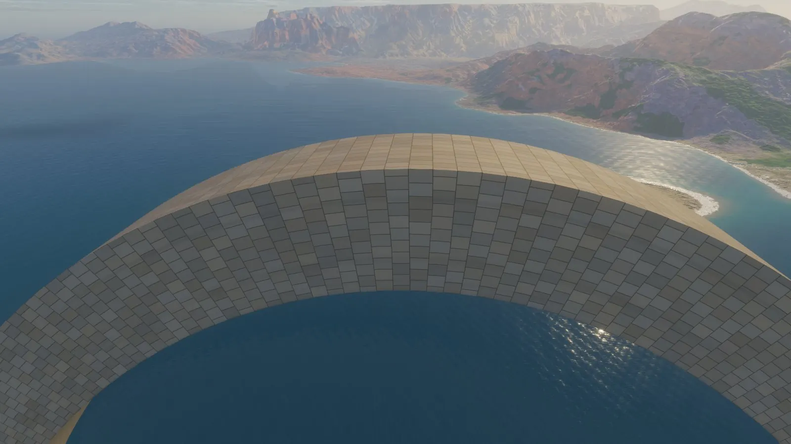
The camera crosses the Rainbow Gate 45 metres above the middle of its crown, 1,250 metres over the sea, and the arch's stones go by underneath in a fraction of a second. It got there by a flight planned whole, from its first metre to its last, before a single frame was drawn: a camera that simply follows the ground, the way a player's does, cannot fly like that.
This post is about three flights over the island and how we learned to plan them: out of a slot canyon into a low sun, over the crown of a colossal arch, and along the Hundred Arches to the Black Shard. It took two wrong takes, a critic and a plan that would have filmed a wall to find out what a camera flight needs from a world.
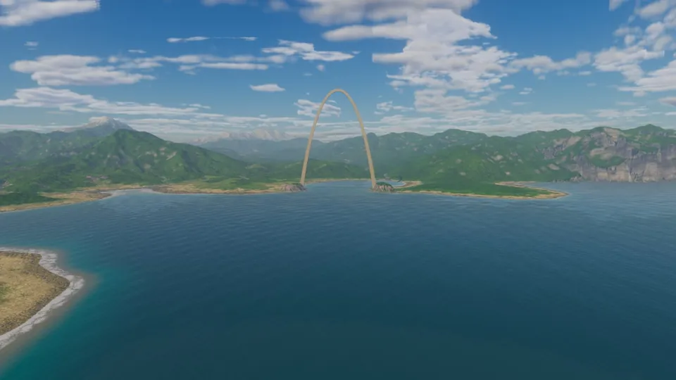
The pass over the Rainbow Gate, 20 seconds (film.rainbow-pass). The camera comes in from the north-east at 950 m, rises through 1,250 m over the crown and sinks to 650 m, 1.4 km beyond it. Its gaze holds the crown until the crown passes under it, then turns back over the bay's west shore to the whole arch, face on. The Gate's crown is a block of stone 27 m square. For the second the camera is over it, the arch's feet stand 1,210 m below it, on two bluffs 895 m apart. The Gate's builder is still another story.
A camera that hops#
The camera a player holds in Atlas orbits a point on the ground. As it moves, that point slides over the land, so every ridge it crosses lifts the camera and every gully drops it. And whatever the camera would dip into, it is pushed up out of, a few metres above the ground under it. In play that is right: the ground is the subject, and the camera keeps it in view. On film it looks like a machine following a line.
A filmed flight has to know what is coming. It rises before a ridge, not as the ridge passes under it; it turns before the canyon bends. So we stopped steering the camera frame by frame. A flight is now planned once, over the real ground, and then every frame of it is rendered.
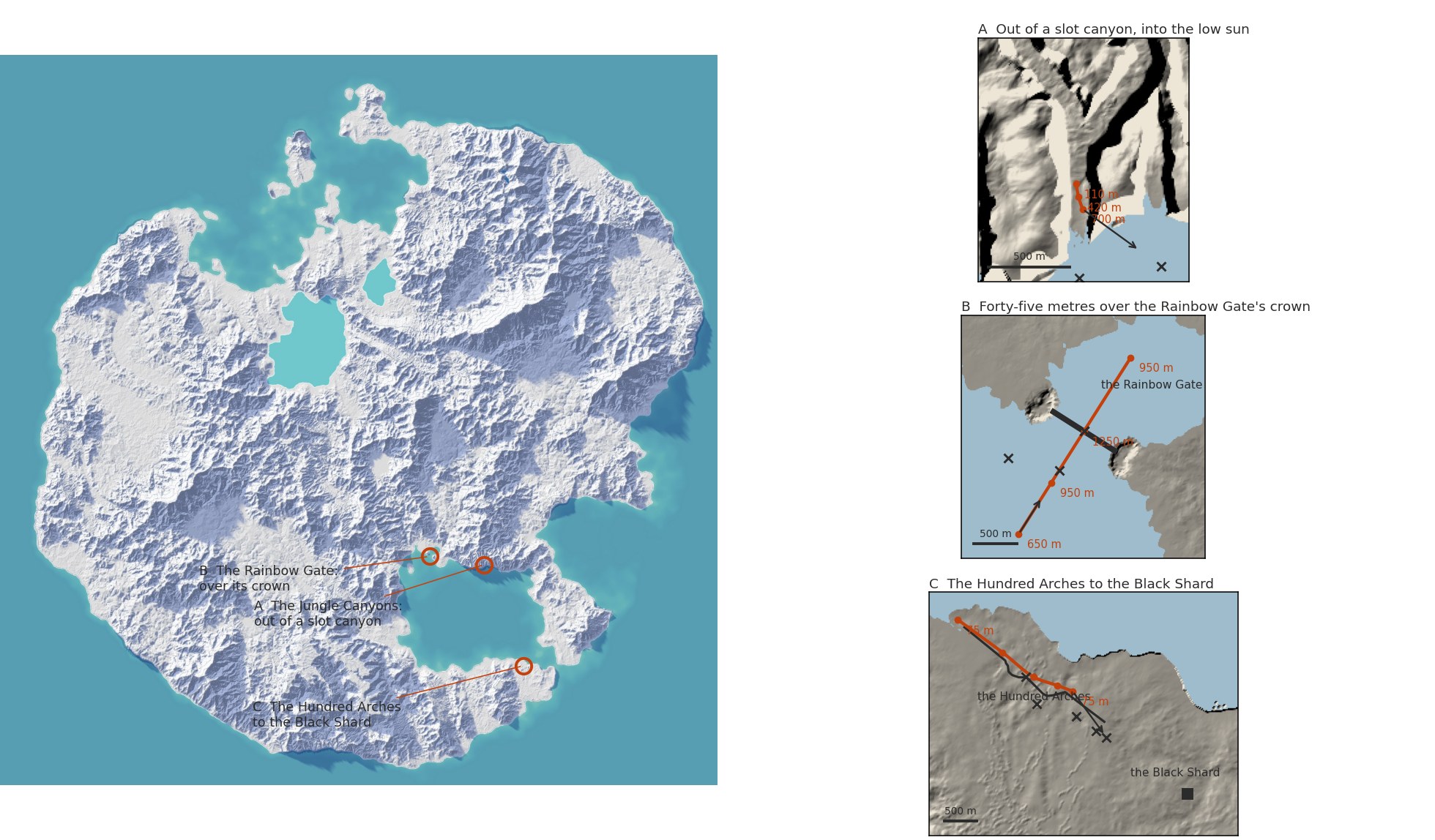
The three flights on the island (left, the paper relief at Atlas aeead1e) and over their own ground (right, the finished ground sampled every 8 to 16 m). Red is the camera's track through its keys, each with its height above the sea; the crosses are the points it looks at; the arrow its last gaze. In A the track is only 160 m long: almost all of that flight is a climb. In C the track runs beside the bridge, never nearer than 63 m.
Take one hung level over a valley#
The plan's first idea was a string. Take the highest ground within reach of the track, add the clearance, and lay a string over the top: let it settle smoothly, never below. We smoothed and raised it sixty times. The first film was perfectly smooth, and wrong. Over a valley 3 km wide the camera never came down: it hung level, 720 m above the valley floor.
A string pulled taut over a row of crests cannot sag between them. Smooth it and raise it often enough and it settles on the crests' upper hull, which is flat across every valley. So take two does it the other way round. It blurs the land under the track into a gentle line that does dip into the valley. Then, wherever that line passes too close to the ground, it adds back only as much height as it needs, blurred, so the lift has no corners.
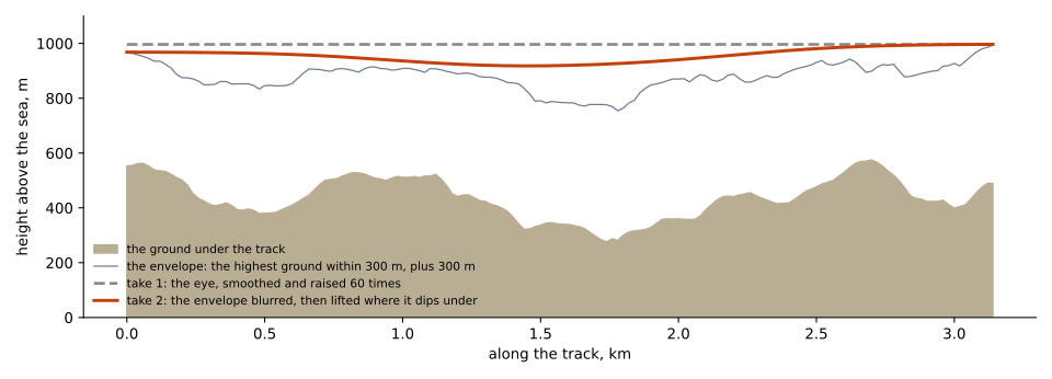
The same 3.2 km track up the great forest's valley, the first two takes. The dashed line is take one, flat at 1,000 m. The orange line is take two: it sinks to about 920 m over the valley, never closer to the land than the envelope (the highest ground within 300 m, plus 300 m). With 300 m of clearance there is little room to sink. In the slot canyon below, the clearance is 15 m.
Out of a slot canyon, into a low sun#
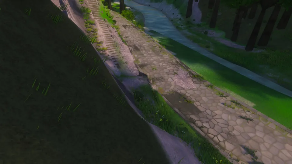
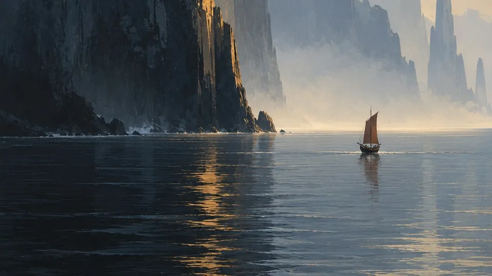
Rising out of a slot canyon of the Jungle Canyons, 18 seconds (film.canyon-rise). It starts 81 m above the canyon floor, looking down the slot to the sea through the canyon's mouth, with the sun behind the east wall. It climbs, the sun clears the east rim 8.4 seconds in, and the camera turns 52° to the left into it, coming out at 700 m in the canyon's mouth. Under the sun, on the horizon, stands the Black Shard, 18.8 km away. The lava it stands on, at most 99 m high, is seen from here almost edge on: a strip 0.3° tall, five pixels of the frame, as dark as the sea around it, so the Shard seems to stand on the water.
The canyon is a deep canyon cut down to the sea on the rainforest east's coast. Where the flight starts it is 160 m wide at its floor, 260 m from rim to rim, and 690 m deep. This flight could not follow the ground at all. It is a tween between three keys: a place and a height for the camera, and a point to look at, for each. The camera passes through its heights on a smooth curve that eases out of the first and into the last.
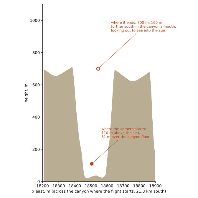
Across the slot canyon where the flight starts, 21.3 km south of the island's middle, to scale. The camera starts in it, 110 m above the sea, and ends 590 m higher and 160 m further south, in the canyon's mouth.
The first cut of this flight stared into the canyon wall for two seconds. Its gaze moved from one look-at point to the next in a straight line, and a turn of more than a right angle sends that line close past the camera, so the view swings across whatever stands between. The gaze now turns by its bearing and its tilt, the short way round, and still lands on each key exactly.
Looking before rendering#
A finished film is about 500 frames, and each one waits for the ground around the camera to be built before it is drawn: about twenty minutes of the machine for one film, and on a busy night an hour or two in the queue for it. So we look at a plan before we render it.
We rendered the first cuts small and showed them to a critic who had never seen the island. Besides the stare at the wall, the canyon film revealed the sea all at once and ended so high that the canyon was lost behind it. After the Gate, the film had no subject. The arches flew under a flat midday sky. We planned the three flights again from those notes.
Then, before rendering them, we cast each frame of each new plan as rays over the island's own ground: no light, no trees, no water, only what stands in the way. The canyon's new plan would have kept a wall of rock in the middle of the frame for eleven of its eighteen seconds, and ended looking out through a narrow gap, with the sun behind the east wall. The canyon runs south to the sea, and the sun stood 31° east of that line. We had planned the ending on the map, not from inside the canyon.
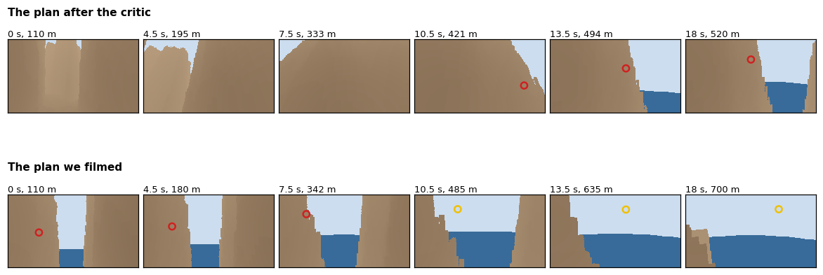
The canyon flight cast as rays over the finished ground, at six moments of its 18 seconds: each pixel is what its ray meets first, rock (darker nearer), sea or sky; the ring is the sun, yellow where it can be seen and red behind rock. Top: the plan after the critic. Bottom: the plan we filmed.
The same look caught two faults in the other plans. The Gate's gaze tipped down toward the far side before the camera had climbed level with the crown, so the crown slipped out of the top of the frame for two seconds just before the crossing. It then turned back nearly 150° in four seconds, too fast to read at 24 frames a second. It now tips down only 28° as it crosses, and turns back at most 26° a second. The arches plan flew 3.3 km in 20 seconds, past arches 62 m away: a flicker, not a glide. It now flies 2.1 km in 24 seconds.
Along the Hundred Arches to the Black Shard#
Along the Hundred Arches to the Black Shard, 24 seconds (film.arches-to-shard, version 2). It opens 75 m up on the bridge's own axis at its mainland end, the deck a line leading to the Shard 4.5 km away. Then it comes down beside the arcade, 46 to 81 m above the sea and never nearer to it than 34 m, its gaze on the bridge 900 to 1,380 m ahead. At the end it lifts its gaze to the Shard, 2.4 km away, with the arches leading in to it from the lower right.
The bridge runs 2.8 km across the lava field of the Lava Tip, from the mainland to the lobe where the Shard, a basalt monolith, stands: a hundred arches, nine towers 14 m tall, a deck between 3 and 61 m above the sea. The camera flies about level with the deck, beside it rather than over it: seen from above, a deck hides its own arches. We filmed it at a sun 7° above the horizon, under more cloud than the other two, so the lava can show its own light.
The first final of this flight ended 110 m up, 400 m short of the bridge's end. There the deck comes down to meet the ground, so its last arches sank out of sight, and from that height the glowing cracks in the lava faded into a dark plain: a slab on an empty table, the very thing the critic had warned of. The film already held a better ending, two seconds earlier, where the arcade leads in from the right toward the Shard's foot. We filmed it again to end there.
Then the critic saw each final beside its first cut, blind to which was which. It chose the canyon's final clearly and the Gate's decisively, but this film's first cut, slightly: that cut opened on the bridge's own axis, the line of arches leading straight to the Shard, and it called that the best frame of either. So we filmed it a third time, opening on that axis and then coming down beside the arcade: that is the film here. Shown blind beside the second take, it won clearly, though from 75 m up the bridge in its first two seconds still reads as a plank, its arches hidden.
What runs#
- Runs: planning a flight over the real ground, by track and clearance or by keys, and filming it as one finished render a frame, at 1920 × 1080 and 24 frames a second. Each frame waits until the ground around the camera has been built, then ten more frames. With six, one frame in 385 caught the sky's light being changed and flashed hazy; with ten, one in about 1,400 still did, 15.2 seconds into the arches film's second take; that one frame has since been rendered again.
- Runs: the films live in the render store beside the island's other renders, each with its flight: the camera of every frame, its light and its size, which films it again frame for frame, and the command that plans it again over the land as it is by then.
- Runs: the ray-cast look at a plan before it is rendered is now a
step of the glide: every flight is cast over the ground it sees, and the
glide warns of a wall in mid-frame, of frames mostly rock and of a gaze
turning faster than 25° a second, and says when the sun is in sight,
before a frame is drawn (
source/raycast.pyis this post's copy). - Not yet: the camera does not bank into its turns, and the clouds hold still: our offline renders stop the clock, so nothing in the sky drifts during a film.
- Runs: the camera a player holds glides too. As it pans, it looks 1.2 seconds ahead along its way and rises before a ridge instead of hopping with the ground under it; at rest it stands on the ground as before. A click on the land turns the gaze to that point.
- Open: the places themselves. The critic found the Gate's stones as flat as tiles, the Shard bronze rather than black and its lava painted on in stripes, the canyon's walls banded like sandstone and without mist, and the bridge's arches knee-high. Those are the island's next work, one place at a time.
The Shard under the sun#
From the canyon's mouth the sun stood 149° round from north, and the Black Shard 154°: under the sun's path, 18.8 km out, beyond 16 km of open sea and the black lava of the Lava Tip.
Who stands on that shore at this hour, and what do they make of it?