Atlas #2 · The island's roads
A Stair at Mavigol That Leads Back Where It Started
Follows on from Atlas #1: Cargo Only Floats Downhill: The River Trade of a Mountain Island
In this post
Below the village of Mavigol, a flight of stone stairs steps 3.8 m off the paved valley road onto the bank and comes back down to the spot it left. Where it meets the road, its slabs, steps and side stones lie heaped against the kerb.
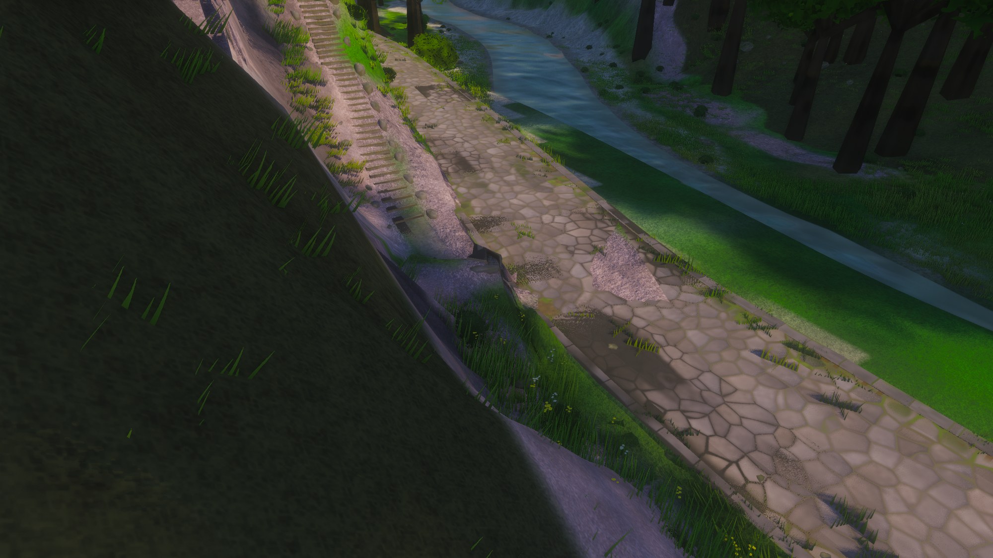
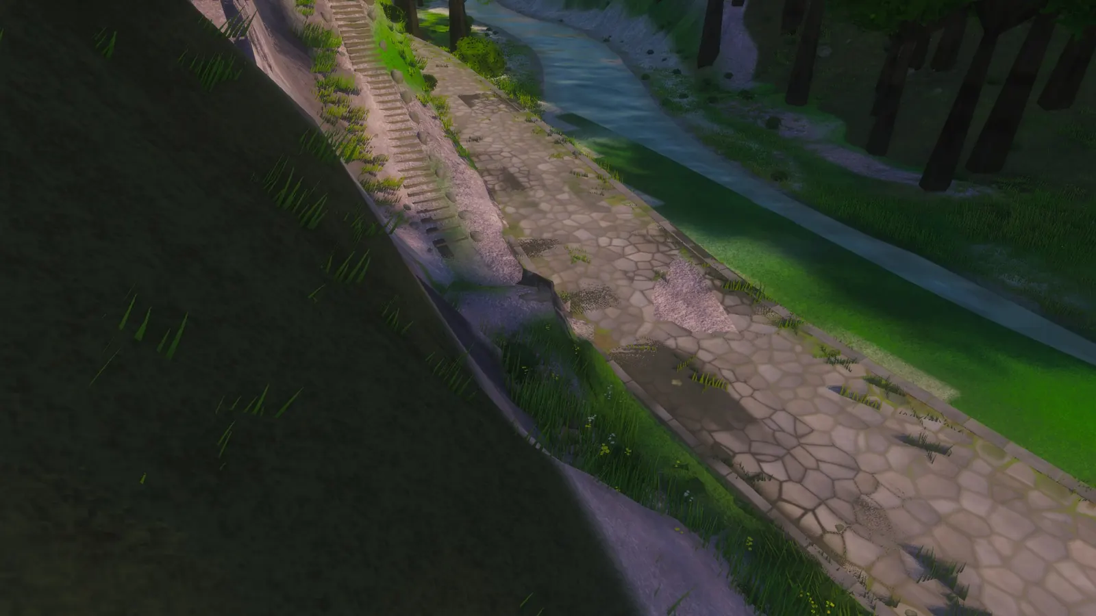
The valley road below Mavigol, looking south. Steps come down the bank on the left. Where they reach the road, just left of centre, the stonework stops making sense. To the right of it, a straight-edged patch of bare ground pokes up through the paving. Atlas e103060b (2026-10-17), lit, with ambient occlusion and contact shadows.
At the foot of the hill#
Mavigol is a Turkish-inspired village of 243 people, inland, a little south of the island's centre, in the Temperate Middle. It sits on a hillside at 262 m. A footpath ramps down from it, and beside the path people's stairs, a flight of stone steps 1.2 m wide, cut straight down for anyone who would rather not walk the bends. Both end at one point on the valley road, 180 m west of the village and 138 m below it.
The road is a stone road, 4.2 m of polygonal paving between 0.3 m kerbs: the game's Roman road. It runs beside a river that falls 57 m in the 3.5 km from Faltersee, 32 m of it in one kilometre. No boat works it. Roads cross those 3.5 km nine times, all by bridge: eight stone arches, all on this road, and one timber trestle 21.7 m over the water on another. Readers of the river post will remember Yaylahisar's nine crossings.
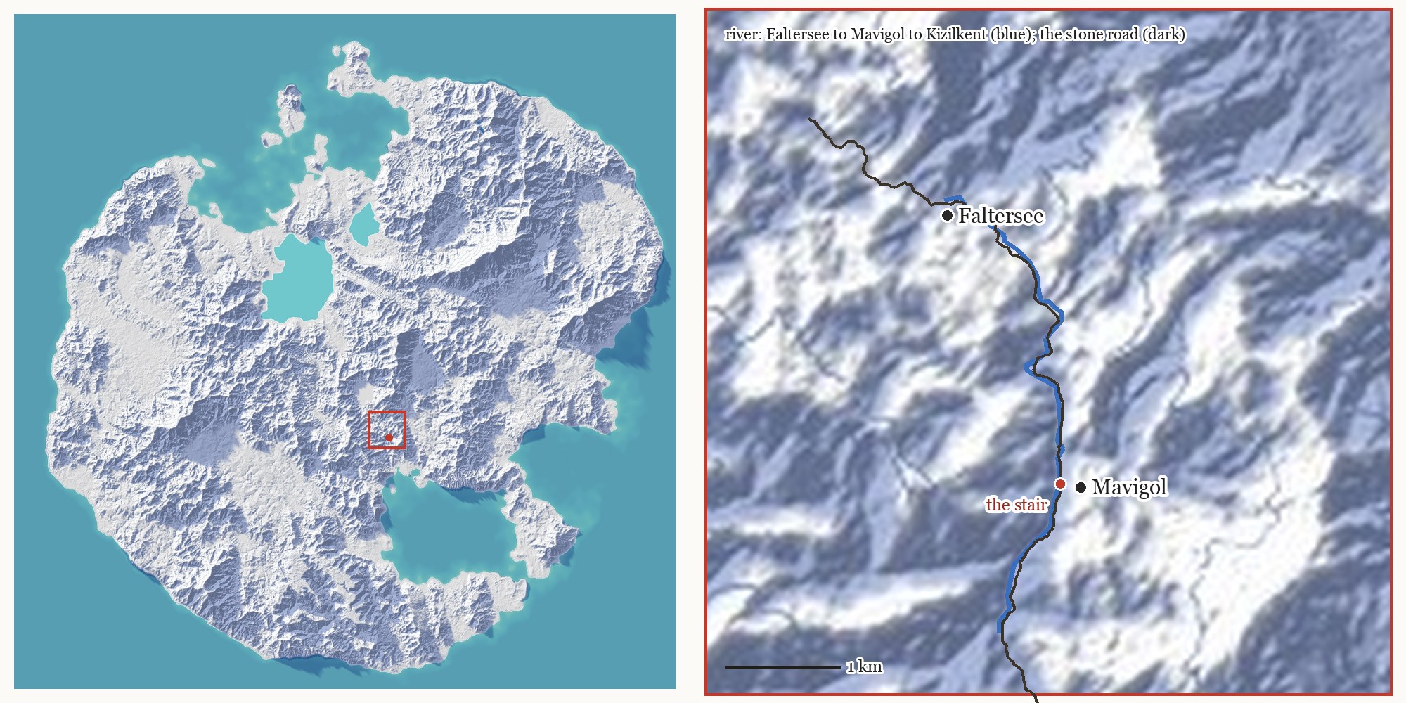
Left: the island on its paper relief (terrain aeead1e), the red square 6 km across. Right: the square. The river is the river post's survey (blue), the stone road dark; at this scale they run as one line. The red dot is the stair, at x 6,809, z 13,706 (x east, z south, in metres).
Come down from Mavigol by either way and you arrive at the heap.
Nobody drew it#
Our road network was grown, not drawn. A program we call the mycelium added the island's settlements one step at a time; each new village sent a road to the network over the cheapest ground, and each road fused with the ones it touched. What it laid is canonical. The roads are kept exactly as recorded and nothing regenerates them, so a road you remember is still there tomorrow.
The record keeps the roads as strokes: one continuous road line, from one meeting point to another. There are 1,572.
The old tools that built roads from the network tidied up as they went, and the tidying was never written down. One of the things they enforced was a standing rule of the team's: roads never ride roads. Roads join at junctions, part, and never come back along the same road. Where a route would leave a road and rejoin it, the router dropped the stretch between, and the old earthworks dropped any sliver under 8 m between two shared stretches. When we began building straight from the record, the tidying stayed behind with the old tools.
The stair below Mavigol is one of the 1,572: stroke 58.
7.8 metres, out and back#
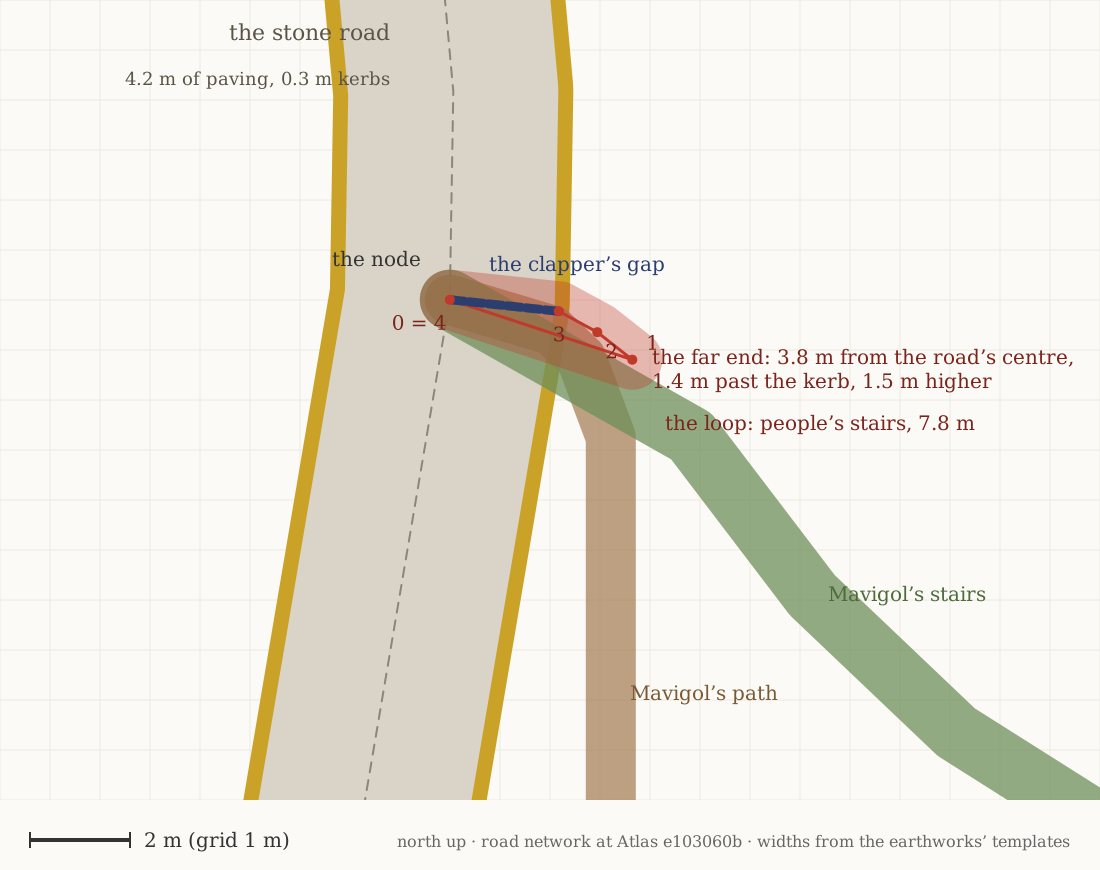
The meeting point in plan, north up, on a 1 m grid. The red line is stroke 58: from point 0 on the road's centreline out to point 1, 3.8 m from the centre and 1.4 m past the kerb, then back through 2 and 3 to the same spot. The dashed blue stretch is the gap its slab bridge was decided over. It lies on the paving.
Stroke 58 is a people's stair of five points and 7.8 m. It rises 1.5 m on the way out and comes down again to the point it started from. Nearly five of its metres lie on the paving or the kerb. Its far end and its way back run within a metre of the last few metres of Mavigol's own path and stairs. Of the island's 1,572 strokes, it is the only one shorter than 8 m.
Built exactly as written#
Stroke 58 got what any short stair gets:
- A tread, 1.2 m wide. Wherever a tread would cover a road it meets, it is trimmed back to the road's edge. Most of this one was trimmed against the kerb.
- Steps, because 1.5 m in under 4 m is about 40 percent, and side stones with them.
- A slab bridge, decided and never built. The record holds a span priced on this stroke, and the crossing table, given a short stone span on a footway, decided a clapper: flat slabs laid end to end on piers of stacked stone, the Dartmoor kind.1 Its 2.2 m gap lies on the paving. The builder put nothing there: under the team's rule, a slab or timber bridge over a dry gap less than 0.8 m deep builds nothing.
Each part followed its rule. Every rule ended at the same kerb.
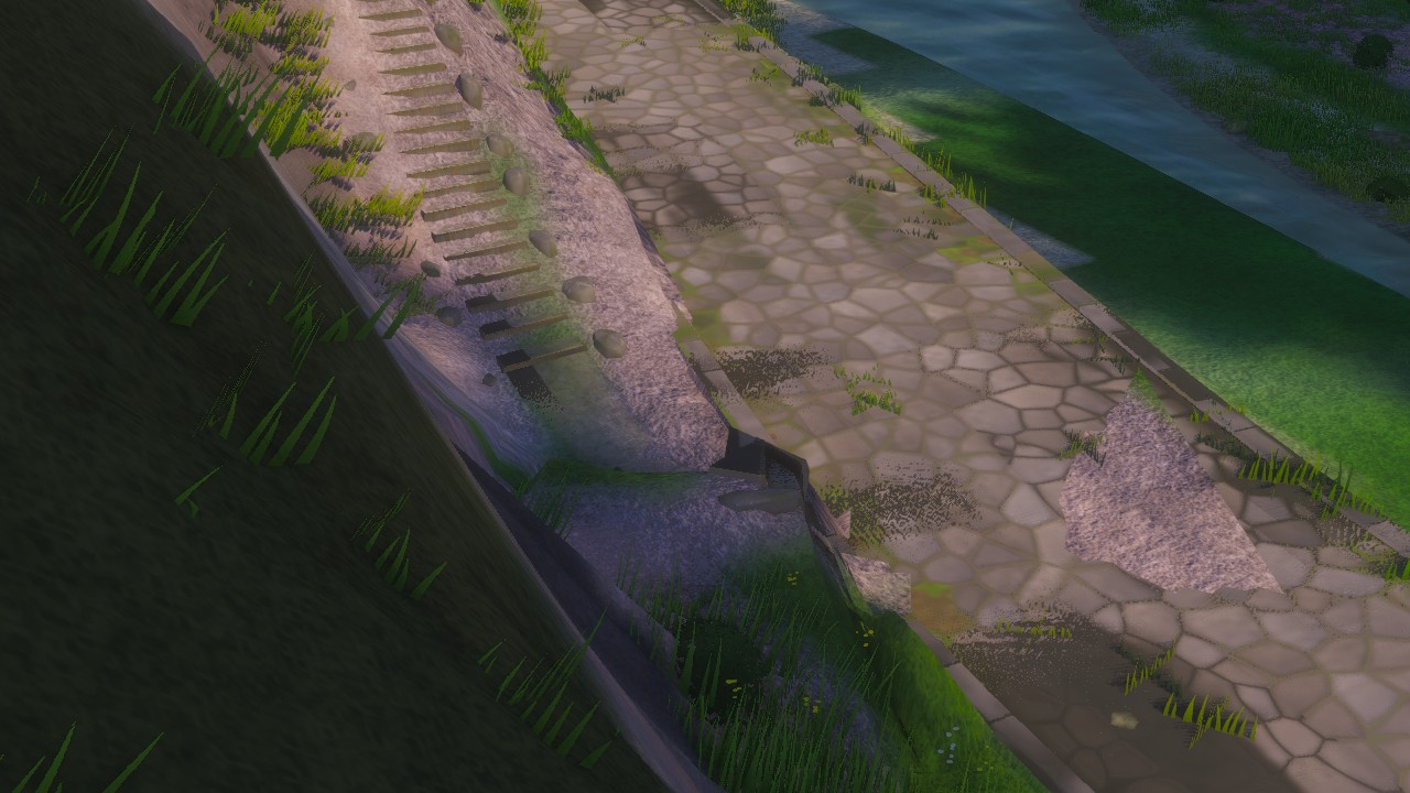
Close up, same frame. The steps on the bank are Mavigol's path, by our reading of the record's lines. Its foot and stroke 58 share the same few square metres of kerb.
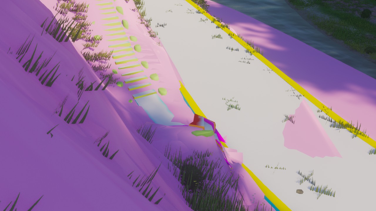
Diagnostic colours: pink ground laid beside a way, white paving, cyan an earthen tread, red a bank side or a tread too steep, yellow the kerb, orange-brown the ends of a flight's slabs, light green stones, magenta a face seen from behind, which should never show. The heap is all stair: its tread, a steep red block, a slab end, a side stone, back faces and a twisted kerb. No bridge part is in it.
Every visual change here goes to a blind critic, an AI shown the render with no hint of what changed and asked to report every artifact it sees. This frame scored 1 of 5, with five major faults. The worst: the junction is "a pile of clipping parts", the red block, the slab end and the loose block, back faces, broken kerb pieces and pink bank shards above the paving. Then the path's foot ending in a lip, the way never joining the road; the patch of bank ground punching through the paving; a strip of back faces in the bank at the top left; and a stepped crease in the trough beside the stair. It knew none of the history. It saw what a player would see.
Un-building one stair#
The fix is the old rule, brought back at the builder: a stroke with no stretch of 8 m off the roads it lies on, and none running off to one of its own ends, rides them and is not built. It finds three on the island. Two carry a decided slab crossing; neither crossing was ever built.
The team has decided: riding strokes are left unbuilt, and those two decisions are dropped from the crossings record in a new version. Decided, not yet built, not on main.
- The road record keeps stroke 58. In the patch under test the builder skips it as a point of zero length, so no other stroke renumbers.
- The crossings record loses two decisions. Nothing on the ground changes from that: both gaps were dry and shallow and built nothing.
- A test loses its subject. The example site for a clapper on people's stairs in the temperate realm was drawn from the decisions, and drew one that never built a clapper. That is how a critic came to look at this spot at all. The cell needs another site.
Forty centimetres of paving#
The hunt turned up a second, general fault. A stair or path ending on a road keeps its steps 2 m from the junction, measured from the road's centreline. A stone road's kerb is 2.4 m out, nearly 2.8 m where a stair meets it at 60 degrees, as Mavigol's own stairs do. So a steep flight can begin on the paving, its treads trimmed to the kerb. The fix under test keeps steps off any ground where the tread and side stones would lie on the met road at its level. How many junctions it changes, the tests will tell.
What runs today, and what does not yet#
In the world today - Stroke 58 and its steps, built at Mavigol from the road record as published (mycelium version 37, step 1,565). Its decided clapper builds nothing. The renders are of Atlas e103060b, the day before. - Stairs whose steps can begin on the paving of the road they end on.
Decided, not yet built or on main - Strokes that ride the roads they meet are left unbuilt; the two slab crossing decisions on them, neither of which builds anything, are dropped from the crossings record in a new version.
Under test - Steps kept off the road a stair or path meets. - Tests: a small network where a copy of the Mavigol loop must ride and a 20 m spur must not; Mavigol itself; island-wide sweeps that allow no riding strokes and no steps on a road.
Next - Before and after renders of this spot and of slanted stairs elsewhere, each to a blind critic, and a new example site for the clapper cell.
Does a path that hugs a road ride it?#
Mavigol's footpath does not lie on the road. For its last 14 m it runs beside it, 1.2 to 2.7 m past the kerb and 2.5 to 5.6 m above it, falling at about 40 percent, and drops onto the road only in its last couple of metres. By the geometry, though, it runs inside the cutting the road dug into the hill, the path's bench notched into the road's cut face. Its steps are the ones in the pictures above. Nobody has yet looked closely for the seam.
The rule never mentions the earthworks a road carries with it. If a path can ride a road's cutting without touching its stones, the old rule reaches further than its four words.
For close readers. The rule is written to catch any stroke that never leaves the roads it lies on. Of the island's 1,572, it caught three: Mavigol's, 7.8 m; one of 17.2 m at x 5,531, z −658; one of 19.5 m at x 21,806, z 21,623. Each of the three ends at the point where it began.
-
The best known stands at Postbridge, over Dartmoor's East Dart: first recorded in the 14th century, thought to have been built in the 13th so that packhorses could carry tin to Tavistock. Postbridge, Wikipedia. ↩