Atlas #4
The Holy City Has a Place Now
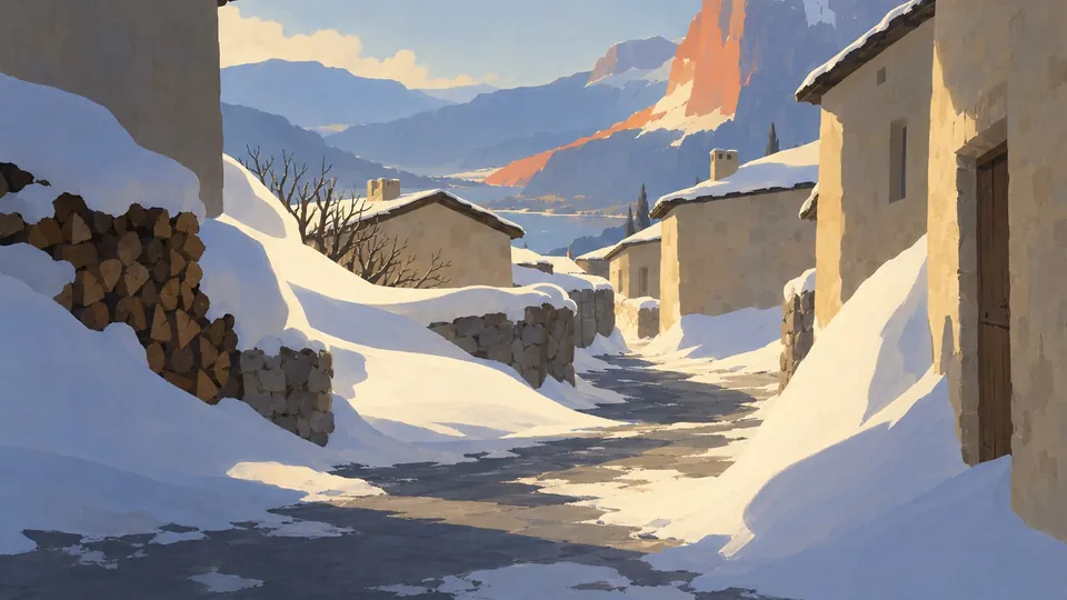
Concept art from the Atlas ontology: Aman Ifrane, roofs enclosing light (concept 400)
Updated 22 October 2026: A fourth layer, at the team's question: the graves in rows again, turned together to the qibla, with an aisle to each domed tomb. The opening count is now layer 4's.
In this post
- Stand at the domed tomb in Casseia
- How we came to be measuring graves
- A bearing, a line, and which way the dead face
- Four layers under Farisiem
- The mosques knew the way first
- The churchyards don't face east either
- Meanwhile: churchyards where none belonged
- What runs, what is fixed, what waits
- A city past the edge of the map
Every Muslim grave on the island is now laid across the way to one city. In the eleven towns laid so far, all 2,294 graves keep to their town's line within a tenth of a degree, and the lines leave the map together, east-south-east, toward a shore no map of the island shows. Until this week the graves agreed on nothing: first they lay in churchyard rows, then along three lines set by how each town happened to be turned. Those directions are mended, and the graves stand in rows again, turned together to the city. Where the lines meet, the island does not say.
These are the generator's example towns, laid and pinned; the game itself does not lay the island's towns yet. It took four layers of the generator to get here: we misread the first, and a question about the third gave us the fourth.
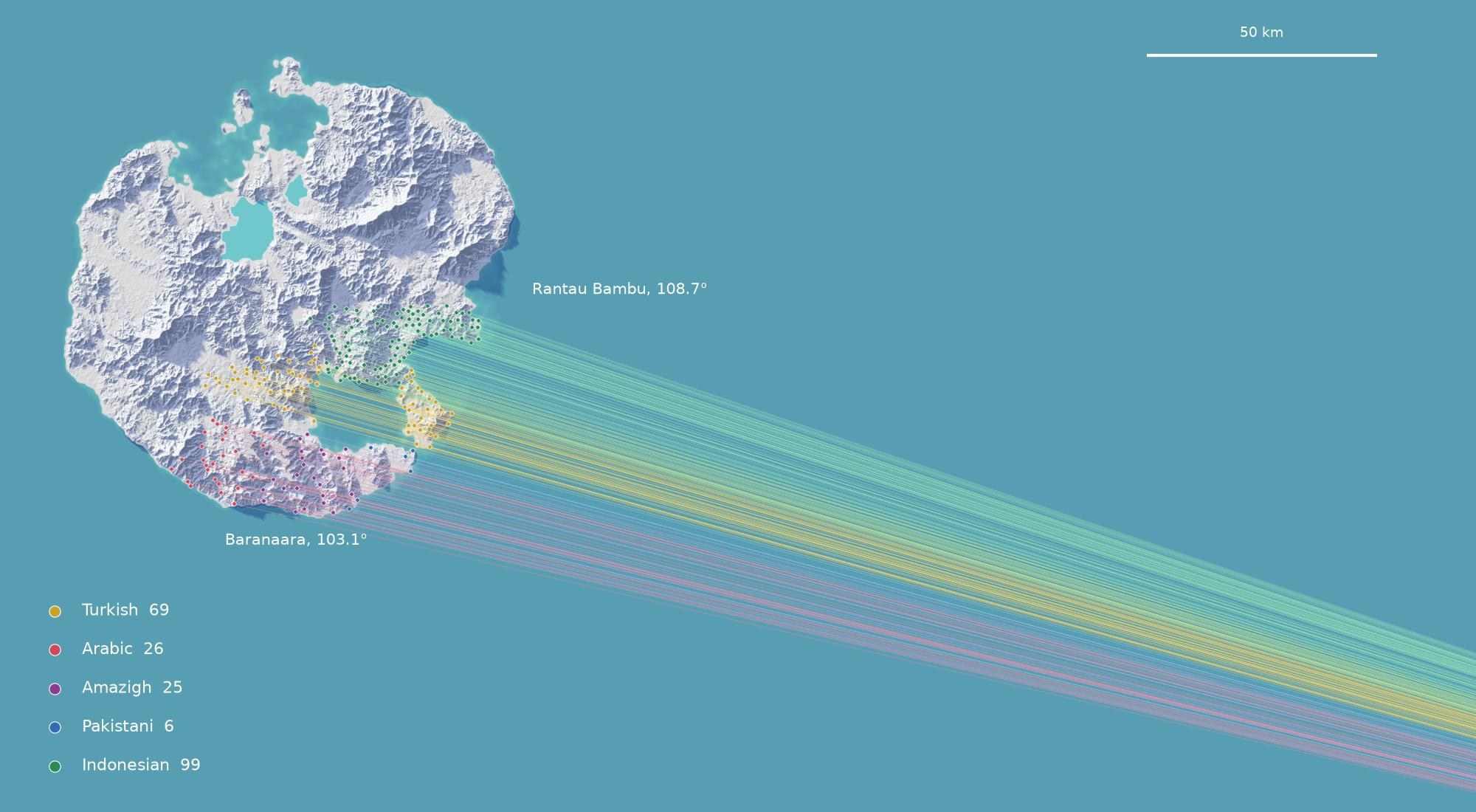
The island on its paper relief (terrain aeead1e) and the sea to the east-south-east. The dots are 225 settlements: the island's 126 of the Islamic tradition and its 99 Indonesian villages, which the generator also gives mosques and buries the Muslim way. They are coloured by people: Turkish gold, Arabic red, Amazigh purple, Pakistani blue, Indonesian green. Each line runs from a settlement along its qibla, the way its dead face, and leaves the map. Seen from the island, the lines fan by 5.6°: Baranaara in the south-west looks along 103.1°, Rantau Bambu in the east along 108.7°. Eleven of them have been laid towards it so far. For the other 214, the line is the way their dead will face once they are.
Stand at the domed tomb in Casseia#
Casseia is an Amazigh city of 10,800 people on the south coast, in a canyon so closed that it needs no wall. Its burial ground holds 103 graves round a domed tomb, 7 m square. Every grave lies on the same line, 13.4° from north, laid so that the dead, on their right side, face 103.4°, a little south of east.
Ride 6.5 km west to Baranaara, an Arabic village of 766 perched on its slope. Its 56 graves lie at 13.1°. Ride on, and the line turns a little from one burial ground to the next: 13.9° at Qamareen, 14.3° at Farisiem, 15.5° at Yukarikale in the Turkish east.
A Muslim cemetery's graves are not laid at random. The dead are laid on their right side, facing the qibla, the direction of the holy city, so a whole cemetery agrees on one line. Neighbouring towns nearly agree with each other, because the city is far away and lies almost the same way from both. Nearly, not exactly: the turn from town to town is how far away the city is.
How we came to be measuring graves#
We did not set out to survey cemeteries. This week the island's town generator laid example towns for every kind of settlement on the island: 59 of them, each a full plan of its buildings, fields, roads and sacred places. A concept artist works from those plans, so that its concept art shows what the generator really builds.
It was the concept artist who stopped. Preparing the ksar of Qamareen, an Arabic fortified village in the sandstone desert, it found a chapel in the plan, and three stations that our table of names called calvaries: a Christian church and, it seemed, Christian wayside crosses, in an Arabic village. That sent us through every grave and shrine in all 59 plans.
A bearing, a line, and which way the dead face#
The numbers in this post are bearings on the game's own map: degrees clockwise from north, with x running east and z south. A grave is a rectangle, 2.2 m by about 1.0 m in a churchyard's rows and 1.9 m by 0.8 m in a Muslim burial ground. Its line is the bearing of its long side. A line has two ends, so 2° and 178° are the same line give or take 4°, and two lines can never be more than 90° apart.
Which way the dead face is a different thing. In Muslim burial the body lies on its right side with its face towards the qibla, so the grave runs across the qibla, at right angles to it.
Four layers under Farisiem#
Farisiem is an Arabic town of 1,221 in the sandstone south. We have its burial ground at four layers of the generator, each pinned so that it can be laid again exactly.
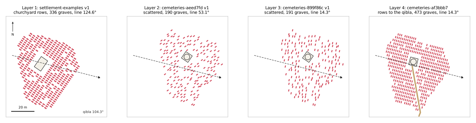
Farisiem's burial ground at the four layers, north up, 90 m square. The dashed arrow is Farisiem's way to the holy city, 104.3°, drawn on every layer for comparison, though only the last two knew it. First: churchyard rows round an 11 m by 7 m chapel. Second: a Muslim burial ground round its domed tomb, its graves along a direction that came from the town's drawing. Third: the same ground, its graves across the arrow. Fourth: the same ground in rows turned to the arrow, an aisle (tan) from the gate to the tomb.
Layer 1, the plans of earlier this week: 336 graves in rows round a chapel, each grave square to its plot, at 124.6°.
We read that line, and the other nine Islamic towns' lines, as ten attempts at a qibla that had come out ten ways, and wrote this post about it. Measured again, every one of the 1,589 graves in the ten towns was 2.2 m long, the size of the generator's churchyard rows, and nine of the ten burial grounds stood round an 11 m by 7 m chapel. The ten towns' dead were buried as Christians. The island's economy asks most towns for a cemetery, and that request chose a churchyard whatever people lived there. The fix came in the next layer: every people now keeps its own burial ground.
Layer 2: 190 graves scattered round a domed tomb, as the generator's Muslim burial ground should be, all at 53.1°. Now the lines were meant as a qibla, but the direction was fixed in the town's own drawing. Siting turns every town to fit its ground, and the direction turned with it. In these lays every turn was a multiple of 45°, so the ten towns could take only four lines, and they took three: 143.1°, 53.1° and 8.1°. Farisiem and Qamareen, Arabic neighbours 5.8 km apart, buried their dead 45° apart. And the graves ran along that direction, head to foot, where a Muslim grave lies across it.
Layer 3, laid on 18 October: 191 graves at 14.3°, across Farisiem's own way to the holy city.
Layer 4, laid on 22 October: the same ground, in rows. Looking at layer 3, the team asked a plain question. The graves had gone from neat rows to a loose scatter by turning; why not turn them together, and keep them packed? At layer 3 every grave already lay on one line. What scattered them was where they stood: a 3 m grid square to the town's drawing, a third of its places left empty and the rest nudged by up to 0.9 m. Each grave turned on its own spot, and the loose grid stayed.
Layer 4 turns the grid with the graves. They stand side by side along the qibla, 1.6 m apart, in rows 2.9 m apart, packed to the wall, about one place in ten left empty. The domed tomb stands square to the qibla on the same rows, and an aisle runs from a gate in the wall to its door, with no grave on it. Farisiem's ground, 2,814 m² inside its wall, now holds 473 graves: a grave to every 5.9 m², where layer 3 gave one to every 14.7 m². Their line is still 14.3°, across the qibla.
| Town | People | Layer 1: churchyard rows | Layer 2: the drawing's direction | Layer 3: across the qibla | The qibla |
|---|---|---|---|---|---|
| Baranaara | Arabic | 171.8° | 8.1° | 13.1° | 103.1° |
| Tinaberkan | Amazigh | 74.5° | 8.1° | 13.3° | 103.3° |
| Casseia | Amazigh | 122.0° | 53.1° | 13.4° | 103.4° |
| Multankhana | Pakistani | 135.1° | 8.1° | 13.6° | 103.6° |
| Qamareen | Arabic | 177.6° | 8.1° | 13.9° | 103.9° |
| Farisiem | Arabic | 124.6° | 53.1° | 14.3° | 104.3° |
| Ksar n'Tidri | Amazigh | 2.1° | 143.1° | 14.7° | 104.7° |
| Aman Ifrane | Amazigh | 122.3° | 53.1° | 14.8° | 104.7° |
| Yukarikale | Turkish | 113.0° | 8.1° | 15.5° | 105.5° |
| Kizilpinar | Turkish | 141.2° | 53.1° | 15.9° | 105.8° |
Each of the first three columns is the line of a town's graves at one layer; the last is the bearing from the town to the holy city. Read down the first column and the lines fill an arc of 108°: those are ten churchyard plots, each turned its own way. The second has three values. The third follows the last, 90° round, to within a tenth of a degree. The scattered style spaces its graves wider than rows do, so the ten grounds hold 989 graves at layer 2 and 1,014 at layer 3. In rows at layer 4 they hold 2,245.
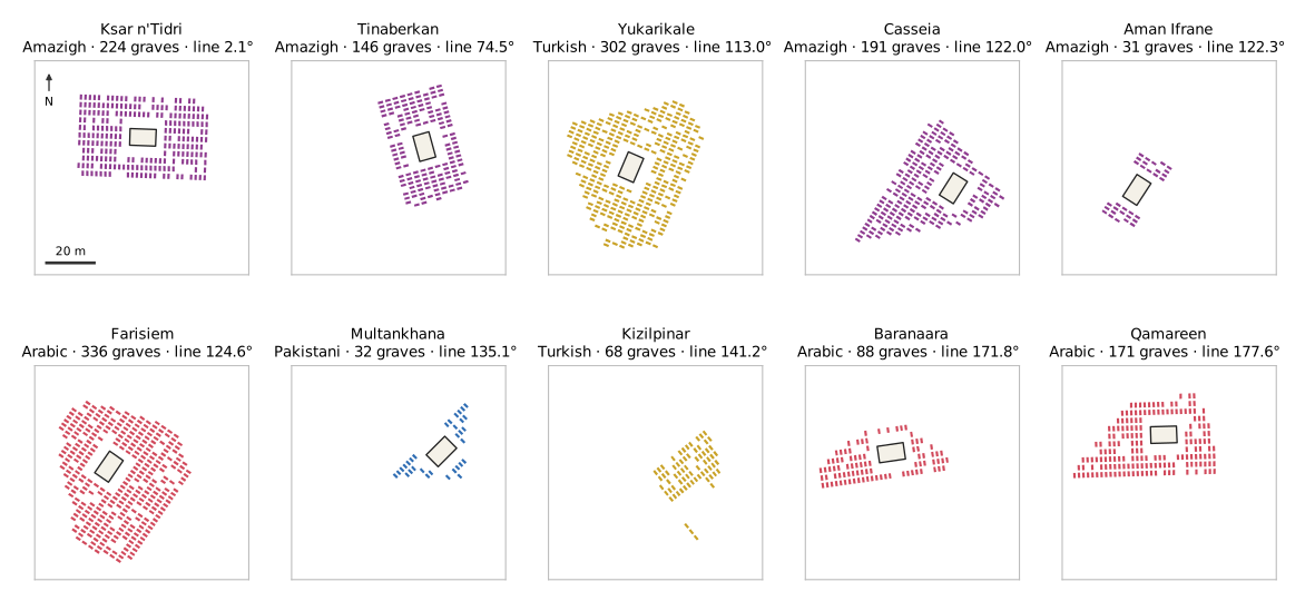
Layer 1: the ten towns' churchyards at one scale, north up, sorted by their line. Kizilpinar, whose name is Turkish for a red spring, has no chapel: it did not fit its ground. Its graves still keep clear of the room the chapel would have taken, and the empty room cuts off three graves to the south. That is a bug. The Muslim burial ground's domed tomb had the same fault, fixed at layer 3; the churchyard's is next on the generator's list.
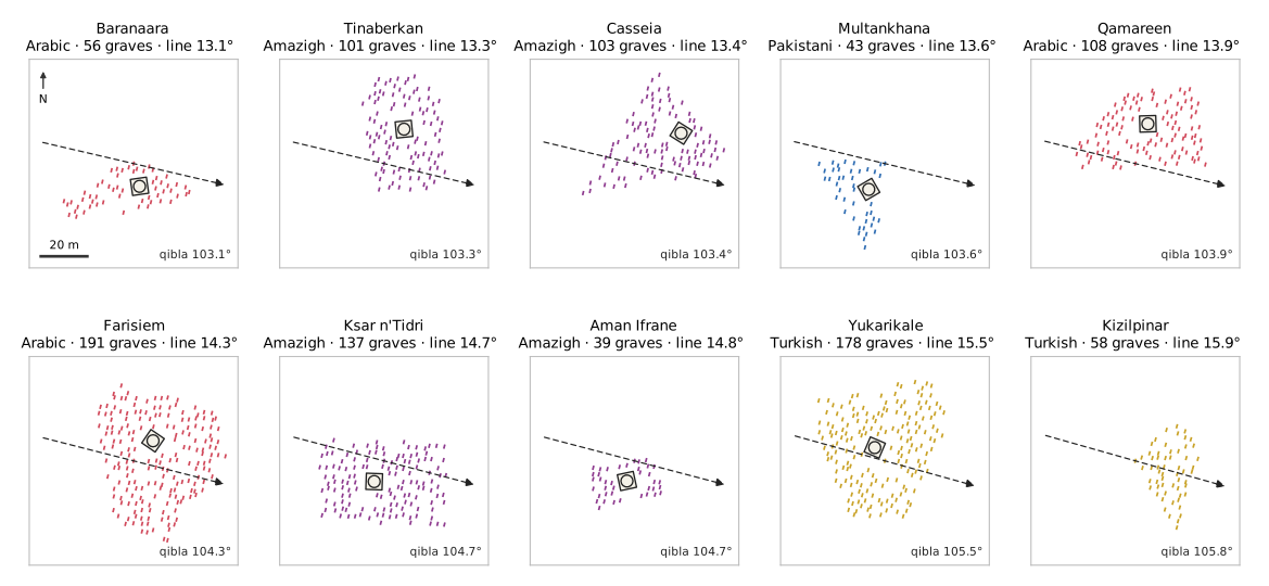
Layer 3: the same ten, sorted by their line, from Baranaara at 13.1° to Kizilpinar at 15.9°. The dashed arrow in each is the town's way to the holy city. The arrows look parallel; across these ten they differ by up to 2.7°. Kizilpinar has no domed tomb at this layer either, and its graves now close over the room it would have taken.
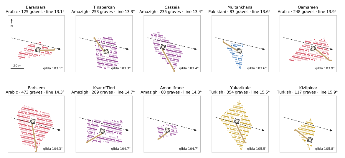
Layer 4: the same ten in rows, turned together to the qibla, each with its aisle (tan) from a gate to the domed tomb, sorted by their line as above. Every grave stands on its ground's rows. Eight of the ten grounds stand where they stood at layer 3, their domed tombs on the same spot; there, 733 graves have become 1,656. The generator moved on between the layers, and two towns were laid a little differently: Casseia's ground stands 129 m from where it was, Yukarikale's 51 m. Kizilpinar has its domed tomb at this layer.
The mosques knew the way first#
In two of the ten, the courtyard villages of Aman Ifrane and Multankhana, the generator also lays a mosque. From the first layer the mosques were laid from the world, not the drawing. The generator held one world direction for the holy city, south-east, turned it back through each town's turn, and laid the prayer hall along it. Both prayer halls lay along 135°, while at layer 2 their graves lay along 53.1° and 8.1°.
Layer 3 gives these graves and mosques one source: the bearing from the town to the city. Aman Ifrane's prayer hall now lies along 104.7°, its graves across it at 14.8°. Multankhana's lies along 103.6°, its graves at 13.6°.
The other towns' mosques have not caught up. They are laid the way any town lays its temple, square to their plots, and their walls stand off the city's line: Yukarikale's by 6.2°, Ksar n'Tidri's by 43.8°. Their dead face the holy city more truly than their prayer halls do. That is a fault, and it is next on the generator's list.
One town at layer 1 had its churchyard rows agree with its mosque. Multankhana's, on the black basalt of the Lava Tip, lay along 135.1°, the line of its prayer hall.
The churchyards don't face east either#
Follow the chain one link further, because the Christians' graves are square to their plots too. In the early Middle Ages the dead in churchyards were commonly laid facing east, feet to the sunrise. Our churchyards lay their graves square to the plot they stand in, and the plot turns with the town. In the layer-1 plans the Celtic village of Strathwych buries its dead at 97.5°, near enough east–west. Llanrhos, another Celtic village, buries them at 6.5°, north–south, across the old custom. Nothing in layers 2 and 3 changed the churchyards' rows.
Meanwhile: churchyards where none belonged#
The same cemetery request reached the island's other peoples who are not Christian, and a second rule gave every temple a churchyard along its walls, except in the four Islamic peoples' towns. The ontology names no tradition yet for the Indonesian, Vietnamese and Andean peoples. The generator's own rules give them their faiths: Indonesian villages build mosques, Vietnamese ones pagodas, Andean ones huacas, and their dead are meant to lie in their own way, scattered or in mounds. Instead their temples got rows of graves round a chapel.
The biggest was at Teluk Pelangi, the city at the mouth of the river where no boat could go in our river post, behind the Rainbow Gate. At layer 1 it had 534 churchyard graves spread over 600 m of the city. At layer 2, with its own burial ground, the temple rule still gave it 455 graves in rows. At layer 3 churchyards belong to the Christian peoples only: Teluk Pelangi's 85 graves lie scattered at 16.6°, across its qibla of 106.6°, and none in rows.
Our own table of names had made it look worse. It listed every grave as a churchyard grave, whatever the faith. Now a grave outside a Christian people's town is a plain cemetery grave. Qamareen's three stations still stand at layer 3, on the processional way up to its domed hill shrine. The generator lays the same 2.5 m stations and the same domed shrine for every people; only the table called the stations calvaries, and now it calls them wayside stations. It still files the domed shrines of the Muslim towns, on the hill and in the burial ground, with the Christian pilgrimage shrines. The concept artist, for its part, had been leaving such things out all along: its approved bird's-eye concept of Teluk Tinggi shows houses on posts and a red flag on the jetty, and no church.
What runs, what is fixed, what waits#
- Laid and pinned: the four layers. Layer 1 is the 59 example towns as they were pinned earlier this week; layers 2 to 4 are the ten Islamic towns and Teluk Pelangi, laid again with each fix. The game itself does not lay the island's towns yet. Laying all 900 waits on a decision about baking the whole island.
- Fixed and laid: every people's own burial ground; churchyards for the Christian peoples only; Muslim graves across the qibla; one holy city for the graves and the courtyard villages' mosques; the graves in rows turned together to the qibla, an aisle to each domed tomb.
- Decided, and proposed: the holy city's place, and with it every town's qibla. The generator lays towards it in layers 3 and 4; the ontology holds it as a proposal. Its name and its kind are not chosen yet.
- To come: the other 48 example towns laid again with these fixes, and pinned.
- Faults, next: the other towns' mosques stand square to their plots, not to the city; a churchyard keeps room for its chapel where the chapel does not fit, as at Kizilpinar; the table files the Muslim towns' domed shrines as Christian pilgrimage shrines.
- Not decided: whether Atlas's Christians bury facing the sunrise.
A city past the edge of the map#
Until this week the island's holy city was only a direction, south-east, and not a place. Now it is a place, across the sea, on a shore no map of the island shows. It has no name yet.
Every Muslim grave on the island lies across a line that ends there. Casseia keeps 145 boats and no quay. Does anyone from the island make the crossing? For now the holy city is known only by the way the island lays its dead.